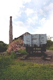
The construction of The Cromford and High Peak Railway was considered to be an engineering masterpiece which attracted railway enthusiasts, not only from this country but all over the world.
It linked High Peak Junction at two hundred and seven-seven feet above sea level with Whaley Bridge at five hundred and seventeen feet. In the middle it rose to over a thousand feet at Ladmanlow. Stretching for Thirty-three miles in length, the line was fully opened in 1831, when it was used to transport minerals, corn, coal and other commodities from one canal to the other.
Following the closure of The Cromford and High Peak Railway, the land was purchased jointly by Derbyshire County Council and the Peak Park Planning Board and in partnership with the Countryside Commission converted into the High Peak Trail. For those wanting a longer walk/ride, the Trail is part of the Midshires Way and the new Pennine Bridleway and Pennine Cycleway.
It stretches form High Peak Junction on the Cromford Canal to Dowlow near Buxton, a total distance of seventeen and a half miles. Surrounded by beautiful countryside the traffic-free trail is ideal for horse riders, cyclists, naturalists and walkers. It is suitable for wheel chairs and pushchairs along the flat sections.
No Comments Yet - Why not be the first to leave a comment
Every effort is made to make sure that all the information is correct but we strongly recommend that you call The High Peak Trail before you set off on your day out to confirm opening times and admission prices.
Please also note that the position on Google maps for The High Peak Trail is a rough estimate using their postcode in the database and might be slightly out.
It may also be worth clicking the web link for The High Peak Trail to see if there are any special events coming up or currently on.


 Middleton Hall